
Well locations of the current Pegis Database with data from Denmark, Norway and UK. The red dots represent the wells referred to as UK Median Line data in the tables below. These contain UK data close to the sector line, naturally belonging the Viking Graben geological province.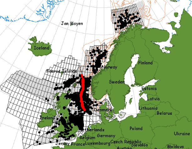
The Pegis database contains a digitized and quality-controlled set of well data within theses categories:
- The data works with all sorts of depth types and are delivered with MDrkb and TVD depths, when well path data are available. The applied well paths are included on the Pegis platform
- Data (and data-averages) from the various search tables can be printed out in Excel format with geographical coordinates (decimal degree and UTM) for application in other systems, e.g. Petrel or 3-D basin modelling software.
- The database contains pdf libraries of core photos and chromatograms/fragmentograms that can be opened from inside tables and graphics.
- The pressure data is “edited” in the respect that the likely trends in a reservoir is selected and delivered together with all the raw data
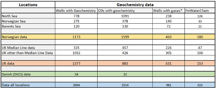
- Wells with geochemistry contains” all types of petroleum geochemistry from RockEval pyrolysis to biomarkers analysed from sediment samples. It also contains gas from headspace and occluded and gas data. Produced or other “flowing” (e.g. MDT) gas samples are sold separately and listed under “Wells with gases”.
- Oils with geochemistry” contains the traditional petroleum geochemical analysis pr oil where one well can have several oils.
- Fm WaterChemistry” contains salinity, density, inorganic ions, etc from formation water analysis.